Seabed Sediment Thickness Contour
Global Seabed Sediment Thickness Contours (km)
"Knowledge of terrestrial and marine sediment thickness is critical to understanding geological evolution and processes. Globally, erosion and biogenic sedimentation followed by transport and deposition by wind or water determines the first-order structure of sedimentary accumulation. Subsequently, sediments can be tectonically deformed, redeposited or even subducted and therefore enter the deep-Earth cycle." (1)Total Sediment Thickness of the World's Oceans and Marginal Seas - Version 3 (GlobSed)
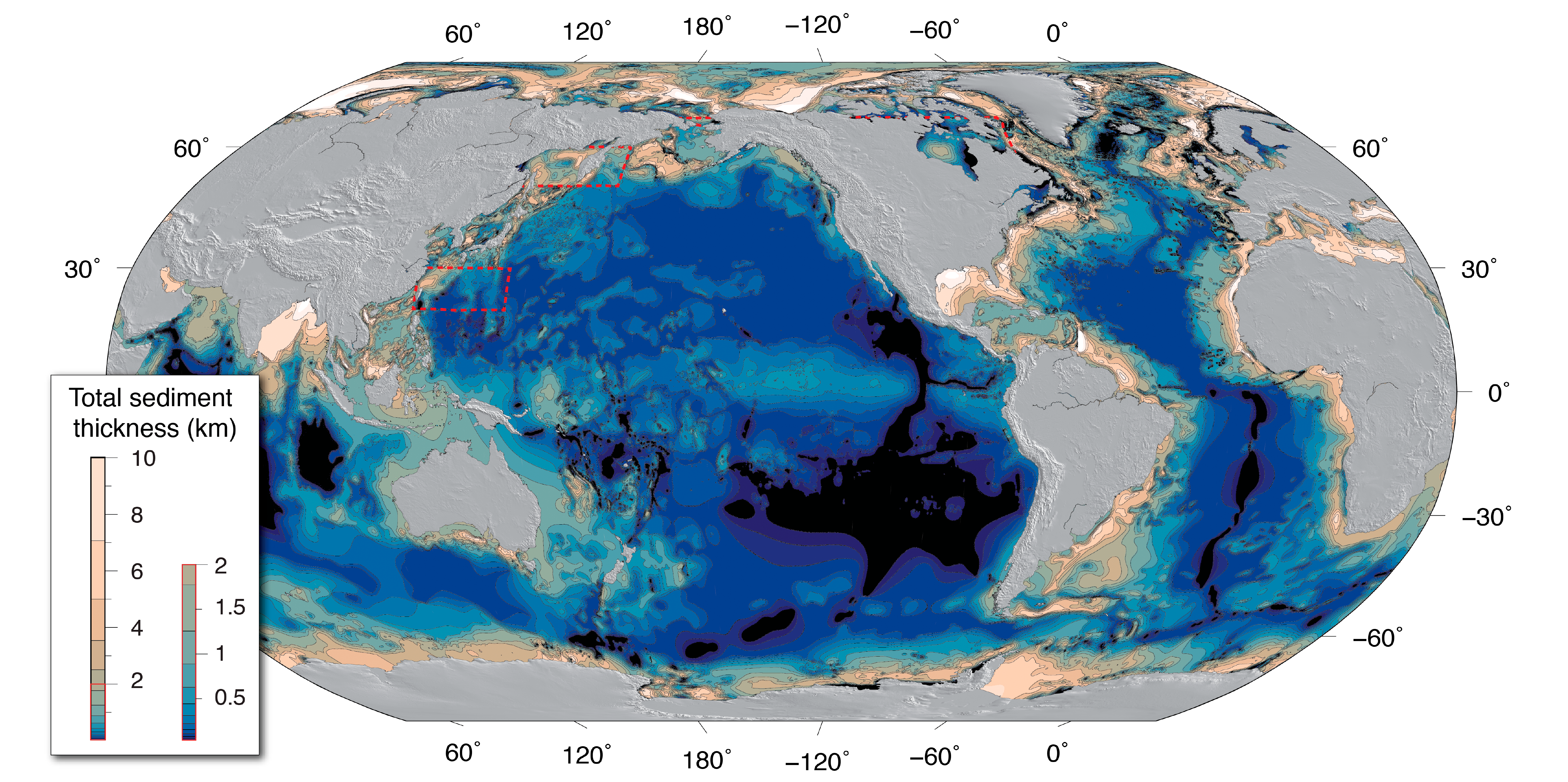
NCEI's global ocean sediment thickness grid of Divins (2003) updated by Whittaker et al. (2013) has been updated again for the NE Atlantic, Arctic, Southern Ocean, and Mediterranean regions.
The new global 5‐arc‐minute total sediment thickness grid, GlobSed, incorporates new data and several regional oceanic sediment thickness maps, which have been compiled and published for the, (1) NE Atlantic (Funck et al., 2017; Hopper et al., 2014), (2) Mediterranean (Molinari & Morelli, 2011), (3) Arctic (Petrov et al., 2016), (4) Weddell Sea (Huang et al., 2014), and (5) the Ross Sea, Amundsen Sea, and Bellingshausen Sea sectors off West Antarctica (Lindeque et al., 2016; Wobbe et al., 2014). This version also includes updates in the White Sea region based on the VSEGEI map of Orlov and Fedorov (2001).
GlobSed covers a larger area than NCEI’s previous global grids (Divins, 2003; Whittaker et al. 2013), and the new updates results in a 29.7% increase in estimated total oceanic sediment volume.
Contours were produced in ArcGIS Pro from the source GlobSed data at 0.5km intervals.
Source
1. DOI: 10.1029/2018GC008115
Datasets available for download
-
Sediment_ContoursFeature Layer
Layer 0 via ArcGIS REST API
-
Sediment_Contours (Explore)HTML
Explore Sediment_Contours on ArcGIS Hub
Additional Info
| Field | Value |
|---|---|
| Last Updated | July 28, 2026, 07:35 (UTC) |
| Created | March 24, 2026, 21:06 (UTC) |
|
Domain / Topic
Domain or topic of the dataset being cataloged.
|
|
|
Title
Title for the Dataset.
|
Seabed Sediment Thickness Contour |
|
Description
A description of the dataset.
|
Global Seabed Sediment Thickness Contours (km) "Knowledge of terrestrial and marine sediment thickness is critical to understanding geological evolution and processes. Globally, erosion and biogenic sedimentation followed by transport and deposition by wind or water determines the first-order structure of sedimentary accumulation. Subsequently, sediments can be tectonically deformed, redeposited or even subducted and therefore enter the deep-Earth cycle." (1)Total Sediment Thickness of the World's Oceans and Marginal Seas - Version 3 (GlobSed)
NCEI's global ocean sediment thickness grid of Divins (2003) updated by Whittaker et al. (2013) has been updated again for the NE Atlantic, Arctic, Southern Ocean, and Mediterranean regions. The new global 5‐arc‐minute total sediment thickness grid, GlobSed, incorporates new data and several regional oceanic sediment thickness maps, which have been compiled and published for the, (1) NE Atlantic (Funck et al., 2017; Hopper et al., 2014), (2) Mediterranean (Molinari & Morelli, 2011), (3) Arctic (Petrov et al., 2016), (4) Weddell Sea (Huang et al., 2014), and (5) the Ross Sea, Amundsen Sea, and Bellingshausen Sea sectors off West Antarctica (Lindeque et al., 2016; Wobbe et al., 2014). This version also includes updates in the White Sea region based on the VSEGEI map of Orlov and Fedorov (2001). GlobSed covers a larger area than NCEI’s previous global grids (Divins, 2003; Whittaker et al. 2013), and the new updates results in a 29.7% increase in estimated total oceanic sediment volume. Contours were produced in ArcGIS Pro from the source GlobSed data at 0.5km intervals. Source 1. DOI: 10.1029/2018GC008115 |
|
Tags / Keywords
Keywords/tags categorizing the dataset.
|
|
|
Format (CSV, XLS, TXT, PDF, etc)
File format of the dataset.
|
|
|
Dataset Size
Dataset size in megabytes.
|
81528.0 |
|
Metadata Identifier
Metadata identifier – can be used as the unique identifier for catalogue entry
|
|
|
Published Date
Published date of the dataset.
|
2022-02-18 |
|
Time Period Data Span (start date)
Start date of the data in the dataset.
|
|
|
Time Period Data Span (end date)
End date of time data in the dataset.
|
|
|
GeoSpatial Area Data Span
A spatial region or named place the dataset covers.
|
| Field | Value |
|---|---|
|
Access category
Type of access granted for the dataset (open, closed, service, etc).
|
public |
|
License
License used to access the dataset.
|
Creative Commons Attribution |
|
Limits on use
Limits on use of data.
|
|
|
Location
Location of the dataset.
|
https://climate.esri.ca/datasets/esri::seabed-sediment-thickness-contour |
|
Data Service
Data service for accessing a dataset.
|
|
|
Owner
Owner of the dataset.
|
esri_oceans |
|
Contact Point
Who to contact regarding access?
|
Esri |
|
Contact Point Email
The email to contact regarding access?
|
|
|
Publisher
Publisher of the dataset.
|
Esri |
|
Publisher Email
Email of the publisher.
|
|
|
Author
Author of the dataset.
|
esri_oceans |
|
Author Email
Email of the author.
|
|
|
Accessed At
Date the data and metadata was accessed.
|
2025-04-03 |
| Field | Value |
|---|---|
|
Identifier
Unique identifier for the dataset.
|
068e763483264050a051dcde2ed6c47f |
|
Language
Language(s) of the dataset
|
English |
|
Link to dataset description
A URL to an external document describing the dataset.
|
https://climate.esri.ca/datasets/esri::seabed-sediment-thickness-contour |
|
Persistent Identifier
Data is identified by a persistent identifier.
|
|
|
Globally Unique Identifier
Data is identified by a persistent and globally unique identifier.
|
|
|
Contains data about individuals
Does the data hold data about individuals?
|
|
|
Contains data about identifiable individuals
Does the data hold identifiable data about individual?
|
|
|
Contains Indigenous Data
Does the data hold data about Indigenous communities?
|
|
|
Portal Type
Platform type of the source portal.
|
| Field | Value |
|---|---|
|
Version
Version of the datatset
|
None |
|
Source
Source of the dataset.
|
None |
|
Version notes
Version notes about the dataset.
|
|
|
Is version of another dataset
Link to dataset that it is a version of.
|
|
|
Other versions
Link to datasets that are versions of it.
|
|
|
Provenance Text
Provenance Text of the data.
|
Esri |
|
Provenance URL
Provenance URL of the data.
|
|
|
Temporal resolution
Describes how granular the date/time data in the dataset is.
|
|
|
GeoSpatial resolution in meters
Describes how granular (in meters) geospatial data is in the dataset.
|
|
|
GeoSpatial resolution (in regions)
Describes how granular (in regions) geospatial data is in the dataset.
|
| Field | Value |
|---|---|
|
Indigenous Community Permission
Who holds the Indigenous Community Permission. Who to contact regarding access to a dataset that has data about Indigenous communities.
|
|
|
Community Permission
Community permission (who gave permission).
|
|
|
The Indigenous communities the dataset is about
Indigenous communities from which data is derived.
|
| Field | Value |
|---|---|
|
Number of data rows
If tabular dataset, total number of rows.
|
7328 |
|
Number of data columns
If tabular dataset, total number of unique columns.
|
5 |
|
Number of data cells
If tabular dataset, total number of cells with data.
|
36640 |
|
Number of data relations
If RDF dataset, total number of triples.
|
|
|
Number of entities
If RDF dataset, total number of entities.
|
|
|
Number of data properties
If RDF dataset, total number of unique properties used by the triples.
|
|
|
Data quality
Describes the quality of the data in the dataset.
|
|
|
Metric for data quality
A metric used to measure the quality of the data, such as missing values or invalid formats.
|
0 Comments